气候 Climate
科本气候分类法 Köppen climate classification
科本气候分类法是目前被最广泛使用的气候分类法,由德国气候学家 Wladimir Köppen 于 1864 年最先提出,后于 1918 年和 1936 年两次修订。
柯本气候分类将气候分为五个主要气候类别。所有气候都被分配了一个一级分类(第一个字母)。
- 一级分类根据降水和温度进行划分,其五个一级分类是 A(热带)、B(干旱带)、C(暖温带)、D(大陆冷温带)和 E(极地带)。
- 除 E 组中的气候外,所有气候都被分配了一个依据季节性降水模式的分类(第二个字母)。
- 系统为除 A 组中的组以外的所有组分配一个温度模式的分类,在 B、C 和 D 中由第三个字母表示,在 E 中由第二个字母表示。
| 1st 一级分类 |
2nd 二级分类 |
3rd 三级分类 |
|---|---|---|
| A (Tropical) (热带/赤道带) |
f (Rainforest) (雨林) |
|
| m (Monsoon) (季风) |
||
| w (Savanna, Dry winter) (稀树草原,冬干) |
||
| s (Savanna, Dry summer) (稀树草原,夏干) |
||
| B (Arid) (干旱带) |
W (Desert) (沙漠) |
|
| S (Steppe) (半干旱草原) |
||
| h (Hot) (炎热) |
||
| k (Cold) (寒冷) |
||
| C (Temperate) (暖温带) |
f (No dry season) (湿地,全年均匀式降水) |
|
| w (Dry winter) (冬干,季风式降水) |
||
| s (Dry summer) (夏干,地中海式降水) |
||
| a (Hot summer) (夏季炎热) |
||
| b (Warm summer) (夏季温暖) |
||
| c (Cold summer) (夏季凉快) |
||
| D (Continental) (大陆性/冷温带,仅北半球) |
f (No dry season) (湿地,全年均匀式降水) |
|
| w (Dry winter) (冬干,季风式降水) |
||
| s (Dry summer) (夏干,地中海式降水) |
||
| a (Hot summer) (夏季炎热) |
||
| b (Warm summer) (夏季温暖) |
||
| c (Cold summer) (夏季凉快) |
||
| d (Very cold winter) (冬季严寒) |
||
| E (Polar) (极地带) |
T (Tundra) (苔原) |
|
| F (Eternal frost (ice cap)) (冰原) |
气候类型分布 Climates around the world
下面呈现全球气候类型分布图。(点击查看大图)

以下为主要城市的气候类型分布表。(横向滚动查看更多)
| 标识 | 科本气候类型 | 中国地理教材13种气候类型 | 中国大陆城市 | 亚洲及大洋洲城市 | 欧洲城市 | 非洲城市 | 南北美洲城市 | 其他 |
|---|---|---|---|---|---|---|---|---|
| Af | Tropical rainforest climate 热带雨林气候 |
热带雨林气候 |
马来西亚 吉隆坡 新加坡 斐济 苏瓦 |
巴西 萨尔瓦多 | ||||
| Am | Tropical monsoon climate 热带季风气候 |
热带季风气候 | 海南琼海 | 孟加拉国 吉大港 中国台湾 台东 印度尼西亚 雅加达 澳大利亚 昆士兰州 凯恩斯 |
塞拉利昂 弗里敦 | 美国 佛罗里达州 迈阿密 多米尼加 圣多明各 |
||
| Aw | Tropical savanna climate with dry-winter characteristics 热带草原气候冬干型 |
热带草原气候 | 海南三亚 | 印度 泰米尔纳德邦 金奈 泰国 曼谷 越南 胡志明市 老挝 万象 |
墨西哥 坎昆 巴西 巴西利亚 |
|||
| As | Tropical savanna climate with dry-winter characteristics 热带草原气候夏干型 |
越南 芽庄 | 肯尼亚 蒙巴萨 | 哥伦比亚 卡利 | ||||
| BWh | Hot desert climate 沙漠气候热型 |
热带沙漠气候 | 沙特阿拉伯 麦加 伊拉克 巴格达 阿联酋 迪拜 巴基斯坦 卡拉奇 |
埃及 开罗 | 美国 亚利桑那州 凤凰城 | |||
| BWk | Cold desert climate 沙漠气候冷型 |
温带大陆性气候 | 新疆吐鲁番 | 叙利亚 大马士革 伊朗 伊斯法罕 土库曼斯坦 阿什哈巴德 |
纳米比亚 纳米布沙漠 沃尔维斯湾 | 阿根廷 巴塔哥尼亚地区 内乌肯 | ||
| BSh | Hot semi-arid climate 半干旱气候热型 |
热带沙漠气候 | 塞浦路斯 尼克西亚 巴基斯坦 拉合尔 荷属阿鲁巴 奥拉涅斯塔德 |
西班牙 巴伦西亚 阿利坎特 | 莫桑比克 马普托 | 美国 夏威夷州 火奴鲁鲁 | ||
| BSk | Cold semi-arid climate 半干旱气候冷型 |
温带大陆性气候 | 河北石家庄 (天津) (西藏拉萨) |
叙利亚 阿勒颇 亚美尼亚 埃里温 |
西班牙 阿拉贡 萨拉戈萨 | 厄立特里亚 阿斯马拉 | 美国 科罗拉多州 丹佛 | |
| Cfa | Humid subtropical climate 亚热带湿润气候 |
亚热带湿润气候 | 广东广州 上海 (重庆) |
韩国 济州岛 日本 东京 日本 大阪府 大阪 澳大利亚 新南威尔士州 悉尼 (中国台湾 台北) |
意大利 伦巴第大区 米兰 意大利 威尼托大区 威尼斯 法国 奥克西塔尼大区 图卢兹 俄罗斯 索契 |
美国 佐治亚州 亚特兰大 美国 佛罗里达州 奥兰多 |
||
| Cfb | Temperate oceanic climate 温带海洋性气候 / Subtropical highland climate with uniform rainfall 亚热带高山气候降雨均匀型 |
温带海洋性气候 | 澳大利亚 维多利亚州 墨尔本 新西兰 惠灵顿 新西兰 奥克兰 |
荷兰 阿姆斯特丹 比利时 布鲁塞尔 德国 柏林 法国 新阿基坦大区 波尔多 丹麦 哥本哈根 英国 英格兰 伦敦 英国 苏格兰 格拉斯哥 爱尔兰 都柏林 |
南非 伊丽莎白港 厄瓜多尔 基多 |
智利 瓦尔迪维亚 哥伦比亚 波哥大 (加拿大 不列颠哥伦比亚省 温哥华) |
||
| Cfc | Subpolar oceanic climate 亚寒带海洋性气候 |
新西兰 奥克兰群岛 | 冰岛 雷克雅未克 丹麦 法罗群岛 |
智利 蓬塔阿雷纳斯 | ||||
| Cwa | Monsoon-influenced humid subtropical climate 亚热带季风气候 |
亚热带季风气候 | 海南海口 四川成都 河南郑州 |
韩国 釜山 中国 香港 越南 河内 缅甸 掸邦 东枝 尼泊尔 加德满都 巴基斯坦 伊斯兰堡 (印度 德里国家首都辖区 新德里) |
赞比亚 卢萨卡 | 阿根廷 科尔多瓦 | ||
| Cwb | Monsoon-influenced temperate oceanic climate 温带季风气候 / Subtropical highland climate 亚热带高山气候 |
高原山地气候 | 云南昆明 云南大理 云南丽江 |
印度 锡金邦 甘托克 不丹 廷布 |
埃塞俄比亚 亚的斯亚贝巴 肯尼亚 内罗毕 马达加斯加 塔那那利佛 南非 约翰内斯堡 |
墨西哥 墨西哥城 秘鲁 库斯科 |
||
| Cwc | Monsoon-influenced subpolar oceanic climate 亚寒带季风气候 / Cold subtropical highland climate 亚热带高山气候冷型 |
(玻利维亚 埃尔阿尔托) | ||||||
| Csa | Hot-summer Mediterranean climate 地中海气候热型 |
地中海气候 | 土耳其 伊兹密尔 黎巴嫩 贝鲁特 以色列 耶路撒冷 塔吉克斯坦 杜尚别 澳大利亚 南澳大利亚州 阿德莱德 |
葡萄牙 里斯本 法国 普阿蓝大区 马赛 法国 普阿蓝大区 尼斯 意大利 坎帕尼亚大区 那不勒斯 意大利 拉齐奥大区 罗马 (希腊 雅典) (意大利 托斯卡纳大区 佛罗伦萨) (西班牙 马德里自治区 马德里) |
摩洛哥 卡萨布兰卡 阿尔及利亚 阿尔及尔 |
美国 加利福尼亚州 萨克拉门托 (美国 加利福尼亚州 洛杉矶) |
||
| Csb | Warm-summer Mediterranean climate 地中海气候温型 |
西班牙 卡斯蒂利亚-莱昂自治区 萨拉曼卡 | 南非 开普敦 | 美国 加利福尼亚州 旧金山 美国 华盛顿州 西雅图 加拿大 不列颠哥伦比亚省 维多利亚 阿根廷 圣卡洛斯-德巴里罗切 |
||||
| Csc | Cold-summer Mediterranean climate 地中海气候冷型 |
高原山地气候 | 冰岛 阿克雷里 挪威 哈尔斯塔 |
美国 夏威夷州 哈莱阿卡拉火山 | ||||
| Dfa | Hot-summer humid continental climate 终年湿润式大陆性气候热型 |
温带大陆性气候 | 哈萨克斯坦 阿拉木图 日本 北海道 札幌 |
罗马尼亚 布加勒斯特 | 美国 伊利诺伊州 芝加哥 (美国 马赛诸塞州 波士顿) (加拿大 安大略省 多伦多) |
|||
| Dfb | Warm-summer humid continental climate 终年湿润式大陆性气候温型 |
挪威 奥斯陆 芬兰 赫尔辛基 乌克兰 基辅 俄罗斯 莫斯科 俄罗斯 圣彼得堡 (瑞典 斯德哥尔摩) (波兰 华沙) |
加拿大 魁北克省 蒙特利尔 加拿大 安大略省 渥太华 美国 缅因州 波特兰 |
|||||
| Dfc | Subarctic climate 终年式大陆性气候亚寒带型 |
亚寒带针叶林气候 高原山地气候 |
瑞士 圣莫里茨 | 美国 阿拉斯加州 安克雷奇 加拿大 纽芬兰与拉布拉多省 拉布拉多 |
||||
| Dfd | Extremely cold subarctic climate 终年式大陆性气候严寒型 |
俄罗斯 维尔霍扬斯克 | ||||||
| Dwa | Monsoon-influenced hot-summer humid continental climate 季风式大陆性气候热型 |
温带季风气候 | 辽宁沈阳 黑龙江哈尔滨 (北京) |
朝鲜 平壤 (韩国 首尔) |
||||
| Dwb | Monsoon-influenced warm-summer humid continental climate 季风式大陆性气候温型 |
黑龙江黑河 吉林延吉 |
韩国 平昌 俄罗斯 符拉迪沃斯托克 |
(加拿大 阿尔伯塔省 卡尔加里) | ||||
| Dwc | Monsoon-influenced subarctic climate 季风式大陆性气候亚寒带型 |
亚寒带针叶林气候 高原山地气候 |
黑龙江漠河 青海玉树 |
俄罗斯 赤塔 | 美国 阿拉斯加州 德尔塔章克申 | |||
| Dwd | Monsoon-influenced extremely cold subarctic climate 季风式大陆性气候严寒型 |
俄罗斯 奥伊米亚康 | ||||||
| Dsa | Mediterranean-influenced hot-summer humid continental climate 地中海式大陆性气候热型 |
温带大陆性气候 | 吉尔吉斯斯坦 比什凯克 土耳其 穆什 |
(美国 犹他州 盐湖城) | ||||
| Dsb | Mediterranean-influenced warm-summer humid continental climate 地中海式大陆性气候温型 |
印度 克什米尔地区 德拉斯 土耳其 锡瓦斯 |
(美国 加利福尼亚州 太浩湖) | |||||
| Dsc | Mediterranean-influenced subarctic climate 地中海式大陆性气候亚寒带型 |
亚寒带针叶林气候 高原山地气候 |
美国 阿拉斯加州 索尔多特纳 | |||||
| Dsd | Mediterranean-influenced extremely cold subarctic climate 地中海式大陆性气候严寒型 |
|||||||
| ET | Tundra climate 极地苔原气候 |
极地苔原气候 | (西藏那曲) | 中国台湾 玉山 日本 富士山 |
挪威 斯瓦尔巴群岛 | 加拿大 努纳武特地区 阿勒特 美国 华盛顿州 雷尼尔山 |
||
| EF | Ice cap climate 极地冰原气候 |
极地冰原气候 | 西藏珠穆朗玛峰 西藏乔戈里峰 |
尼泊尔 干城章嘉峰 | 加拿大 育空地区 洛根山 阿根廷 阿空加瓜山 |
南极洲 阿蒙森-斯科特站 南极洲 东方站 |
||
| 注:括号中的地点,位于两种气候类型的分界线附近。 | ||||||||
References
Köppen climate classification from Wikipedia
生物地理 Biogeography
生物地理区域 Biogeographical divisions
生态区(Ecoregion)是由生态和地理定义的区域。一个区域内重复出现的生态系统,加上那个地区特有的土壤和地貌特征,就构成了一个生态区。
生态区的范围小于生物区(Bioregion),而生物区又小于生物地理界(Biogeographic realm)。生物地理分区也可称作生物大区(Ecozone),目前公认世界上一共有八个生物地理界。
地球的八个生物地理界 The eight biogeographic realms of the world
下面呈现全球生物地理界分布图。(点击查看高清矢量图)

以下为全世界的生物地理界和其下属的生物区列表。值得注意的是,生物地理界的划分是学界公认的,而这里的生物区的划分只是一种粗略的划分方式。
| 生物地理界 Biogeographic realm |
面积(百万平方公里) Area million square kilometres |
分布 Lands included |
生物区 Bioregions |
|---|---|---|---|
| 古北界 Palearctic PA |
54.1 | 欧亚大陆之大部分和非洲北部 The bulk of Eurasia and North Africa. |
东亚(从喜马拉雅到北极圈) East Asia north of the Himalayan system's foothills to the Arctic |
| 喜马拉雅 Himalayan |
|||
| 青藏高原草原 Tibetan Plateau steppe |
|||
| 云贵高原 Yunnan-Guizhou Plateau |
|||
| 东北亚 Northeast Asia |
|||
| 俄罗斯远东 Russian Far East |
|||
| 中亚(从伊朗高原到北极圈) Central Asia - Iranian Plateau and north to the Arctic. |
|||
| 温带亚洲 Temperate Asia biocountry |
|||
| 蒙古高原 Mongolian Plateau |
|||
| 欧亚大草原 Eurasian Steppe |
|||
| 亚洲——西伯利亚区域 Asian-Siberian region |
|||
| 西亚 Western Asia |
|||
| 阿拉伯沙漠 Arabian Desert |
|||
| 黎凡特 Mediterranean Near East (roughly corresponds to the Levant) |
|||
| 安纳托利亚 Anatolian Plateau |
|||
| 南高加索 Transcaucasia |
|||
| 北非 Northern Africa |
|||
| 大西洋沿岸沙漠 Atlantic coastal desert |
|||
| 撒哈拉沙漠 Sahara Desert |
|||
| 马格里布 Mediterranean Maghreb |
|||
| 阿特拉斯山脉 Atlas montane |
|||
| 欧洲 Europe |
|||
| 欧洲地中海平原 European Mediterranean Basin |
|||
| 伊比利亚半岛 Iberian Peninsula |
|||
| 巴尔干半岛 Balkan Peninsula |
|||
| 北高加索 North Caucasus |
|||
| 阿尔卑斯山脉 Alps montane |
|||
| 喀尔巴阡山脉 Carpathians |
|||
| 斯堪的纳维亚 Scandinavia |
|||
| 俄罗斯欧洲部分 European Russia |
|||
| 欧洲——西伯利亚区域 Euro-Siberian region |
|||
| 马卡罗尼西亚 Macaronesia |
|||
| 新北界 Nearctic NA |
22.9 | 北美洲绝大部分(包括格陵兰岛) Greenland and most of North America. |
加拿大地盾 Canadian Shield |
| 北美洲东部 Eastern North America |
|||
| 北墨西哥、西南美国 Northern Mexico and Southwestern United States |
|||
| 北美洲西部 Western North America |
|||
| 埃塞俄比亚界 Afrotropic AT |
22.1 | 撒哈拉以南非洲(包括马达加斯加岛)和阿拉伯半岛 Trans-Saharan Africa, Madagascar and Arabia. |
西非、萨赫勒 Western Africa and Sahel |
| 中部非洲 Central Africa |
|||
| 东非、南部非洲 Eastern and Southern Africa |
|||
| 非洲之角 Horn of Africa |
|||
| 马达加斯加——印度洋 Madagascar-Indian Ocean |
|||
| 新热带界 Neotropic NT |
19 | 南美洲(包括福克兰群岛)、中美洲及加勒比地区,以及佛罗里达州南部 South America, Central America, the Caribbean, South Florida and the Falkland Islands. |
亚马孙 Amazonia |
| 加勒比 Caribbean |
|||
| 中美洲 Central America |
|||
| 中安第斯 Central Andes |
|||
| 南美洲东部 Eastern South America |
|||
| 佛罗里达大沼泽 Everglades |
|||
| 北安第斯 Northern Andes |
|||
| 奥里诺科 Orinoco |
|||
| 南锥体 Southern South America |
|||
| 澳新界 Australasia AU |
7.6 | 澳大利亚、新西兰、美拉尼西亚之大部分(包括几内亚岛,不含斐济群岛)、小巽他群岛、苏拉维西岛 Australia, Melanesia, New Zealand, Lesser Sunda Islands, Sulawesi and the neighbouring islands. The northern boundary of this zone is known as the Wallace Line. |
澳大利亚 Australia |
| 新几内亚、美拉尼西亚 New Guinea and Melanesia |
|||
| 新西兰 New Zealand |
|||
| 瓦拉西亚 Wallacea |
|||
| 东洋界 Indomalaya IM |
7.5 | 印度次大陆、东南亚、中国南部,以及大巽他群岛的大部分(包括婆罗洲、爪哇岛、苏门答腊,不含苏拉威西岛) The Indian subcontinent, Southeast Asia, southern China and most of the Greater Sunda Islands. |
印度次大陆 Indian subcontinent |
| 印度支那 Indochina |
|||
| 巽他陆棚、菲律宾群岛 Sunda Shelf and Philippine Archipelago |
|||
| 大洋界 Oceania OC |
1 | 波利尼西亚(新西兰除外)、密克罗尼西亚,以及斐济 Polynesia (except New Zealand), Micronesia, and the Fijian Islands. |
密克罗尼西亚 Micronesia |
| 波利尼西亚 Polynesia |
|||
| 南极界 Antarctic AN |
0.3 | 南极洲(包含亚历山大岛)、南乔治亚和南桑威奇群岛 Antarctica, Alexander Island, South Georgia and the South Sandwich Islands. |
“Bioregions 2020”框架 The Bioregions 2020 framework
非政府组织 One Earth 提出了一种新的的划分框架,名为 Bioregions 2020。生物地理界区域、生物地理亚界的概念在此框架中新增,但这两个概念除便于划分外并没有太多实际的意义。
在该框架下,生态地理分区从大到小依次为:
- 生物地理界(Biogeographic realm)
- 生物地理界区域(Biogeographic realm division)
- 生物地理亚界(Biogeographic subrealm)
- 生物区(Bioregion)
- 生态区(Ecoregion)
生物地理亚界分布 Biogeographic subrealms of the world
下面呈现全球生物地理亚界分布图。(点击查看大图)

以下为全球生物地理亚界列表。
| 生物地理界 Biogeographic realm |
生物地理界区域 Biogeographic realm division |
生物地理亚界 Biogeographic subrealm |
编号 # |
|---|---|---|---|
| 新北界 Nearctic |
亚寒带北美洲 Subarctic America |
格陵兰岛 Greenland (cyan) |
1 |
| 加拿大冻原 Canadian Tundra (blue) |
2 | ||
| 阿拉斯加 Alaska (indigo) |
3 | ||
| 加拿大针叶林 Canadian Boreal Forests (purple) |
4 | ||
| 北美洲 Northern America |
美西海岸 North Pacific Coast (blue-green) |
5 | |
| 美西山地 American West (brown) |
6 | ||
| 北美大平原 Great Plains (gold) |
7 | ||
| 美东北森林 Northeast American Forests (green) |
8 | ||
| 美东南草原、森林 Southeast U.S. Savannas & Forests (orange) |
9 | ||
| 墨西哥旱地 Mexican Drylands (olive) |
10 | ||
| 新热带界 Neotropic |
中美洲 Central America |
中美洲 Central America (light green) |
11 |
| 加勒比 Caribbean (green) |
12 | ||
| 南美洲 Southern America |
南美洲上部 Upper South America (pale green) |
13 | |
| 亚马孙 Amazonia (deep green) |
14 | ||
| 巴西塞拉多&大西洋海岸 Brazil Cerrado & Atlantic Coast (tan) |
15 | ||
| 南美洲草地 South American Grasslands (yellow) |
16 | ||
| 南美洲安第斯&太平洋海岸 Andes Mountains & Pacific Coast (dark green) |
17 | ||
| 大洋界 Oceania |
大洋界 Oceania |
大洋洲诸岛 Oceanic Islands (green) |
18 |
| 埃塞俄比亚界 Afrotropics |
埃塞俄比亚界 Afrotropics |
马达加斯加&东非海岸 Madagascar & East African Coast (bright green) |
19 |
| 非洲南部 Southern Afrotropics (rust) |
20 | ||
| 非洲中部 Central / Sub-Equatorial Afrotropics (orange) |
21 | ||
| 非洲赤道部分 Equatorial Afrotropics (emerald green) |
22 | ||
| 撒哈拉以南非洲 Sub-Saharan Afrotropics (tan) |
23 | ||
| 古北界 Palearctic |
欧亚大陆南部 South Eurasia |
北非 North Africa (red-orange) |
24 |
| 泛阿拉伯半岛 Greater Arabian Peninsula (beige) |
25 | ||
| 欧亚大陆西部 West Eurasia |
地中海 Mediterranean (red) |
26 | |
| 黑海森林、草原 Black Sea Forests & Steppe (gold) |
27 | ||
| 欧洲山地森林 European Mountain Forests (dark green) |
28 | ||
| 泛欧洲森林 Greater European Forests (green) |
29 | ||
| 不列颠群岛 British Isles (emerald green) |
30 | ||
| 欧亚大陆亚寒带部分 Subarctic Eurasia |
古北界冻原 Palearctic Tundra (teal) |
31 | |
| 斯堪的纳维亚&西部亚寒带针叶林 Scandinavia & Western Boreal Forests (purple) |
32 | ||
| 西伯利亚&东部亚寒带针叶林 Siberia & Eastern Boreal Forests (plum) |
33 | ||
| 鄂霍次克海&白令冻原、针叶林 Sea of Okhotsk & Bering Tundra/Taiga (lavender) |
34 | ||
| 欧亚大陆东部 East Eurasia |
日本列岛 Japanese Islands (dark green) |
35 | |
| 东北亚森林 Northeast Asian Forests (grey-green) |
36 | ||
| 蒙古草原 Mongolian Grasslands (yellow) |
37 | ||
| 东亚中部森林 Central East Asian Forests (pale green) |
38 | ||
| 喜马拉雅&青藏高原 Himalayas & Tibetan Plateau (tan) |
39 | ||
| 东亚荒漠 East Asian Deserts (red-brown) |
40 | ||
| 阿尔泰-萨彦山脉 Altai-Sayan Mountains (olive green) |
41 | ||
| 欧亚大陆中部 Central Eurasia |
哈萨克草原、寒温带森林 Kazakh Steppes & Hemiboreal Forests (chartreuse) |
42 | |
| 里海&中亚荒漠 Caspian Sea & Central Asian Deserts (brown) |
43 | ||
| 天山山脉 Tien Shan Mountains (tan) |
44 | ||
| 波斯荒漠、森林 Persian Deserts & Forests (dark red) |
45 | ||
| 东洋界 Indomalaya |
东洋界 Indomalaya |
印度次大陆 Indian Subcontinent (light green) |
46 |
| 东南亚森林 Southeast Asian Forests (emerald green) |
47 | ||
| 马来西亚&西印尼 Malaysia & Western Indonesia (dark green) |
48 | ||
| 澳新界 Australasia |
澳新界 Australasia |
澳新界诸岛&东印尼 Australasian Islands & Eastern Indonesia (olive green) |
49 |
| 澳大利亚 Australia (red) |
50 | ||
| 新西兰 New Zealand (green) |
51 | ||
| 南极界 Antarctica |
南极界 Antarctica |
南极大陆和岛屿 Antarctic Continent & Islands (not shown) |
52 |
生物区分布 Bioregions of the world
生物区的编号格式为两位字母+两位数字。比如,长江平原常绿林生物区(Chang Jiang Plain Evergreen Forests Bioregion)的编号为 PA50,其前两位字母表示该生物区属于古北界(Palearctic, PA),后面的数字表示该生物区是古北界的第 50 个生物区。
下面呈现全球生物区分布图。(点击查看大图)

生态区分布 Ecoregions of the world
对于生态区层面的划分,世界自然基金会(World Wide Fund for Nature, WWF)将世界分为
- 867个陆地生态区(Terrestrial ecoregion)
- 232个海洋生态区(Marine ecoregion)
- 426个淡水生态区(Freshwater ecoregion)
Bioregions 2020 框架沿用了这种划分。
通常来说,一个生物区旗下含有多个生态区。生态区一般直接由其名称表示,编号没有统一的定义。WWF 曾使用两位字母+四位数字的编号格式,而 One Earth 直接使用 “所属生物区编号 - 生态区子序号” (Bioregion Label - Ecoregion Seriel )的表示方法。比如,长江平原常绿林生态区(Changjiang Plain Evergreen Forests Ecoregion,与其所在生物区同名)的 WWF 编号为 PA0415,而 One Earth 则表示为 PA50 - 2,即编号为 PA50 的生物区内的第 2 个生态区。
生物群系 Biomes
生物群系(Biome)是由生物和地理定义的区域。在区域的气候条件,以及相似的地理条件下生活的一组生物群落,构成了一个生物群系。
生物群系是一个比栖息地(Habitat)更广泛的概念。 一个生物群系可以包含多个栖息地。
生物群系与生态区这两个概念紧密相连。通常来说,一个生态区对应以下提到的14种生物群系中的一种。
生物群系分布 Biomes around the world
下面呈现全球生物群系的分布图。(点击查看高清矢量图)

| 五分类法 Pentachotomy |
一般分类 Casual Classification |
WWF分类 Classification by WWF |
分布图 Maps |
|---|---|---|---|
| Tundra | 北极冻原 Arctic tundra |
冻原 Tundra |
 |
| 南极冻原 Antractic tundra |
|||
| 高山冻原 Alpine tundra |
|||
| Forest | 亚寒带针叶林 Taiga / Boreal forest |
亚寒带针叶林 Taiga / Boreal forest |
 |
| 温带森林 Temperate forest |
温带阔叶林、混交林 Temperate broadleaf and mixed forests |
 |
|
| 温带针叶林 Temperate coniferous forest |
 |
||
| 地中海森林、疏林、灌丛 Mediterranean forests, woodlands, and scrub |
 |
||
| 热带森林 Jungle / Tropical forest |
常绿阔叶林 / 热带雨林 (Sub)Tropical moist broadleaf forests |
 |
|
| 旱生阔叶林 (Sub)Tropical dry broadleaf forests |
 |
||
| (亚)热带针叶林 (Sub)Tropical coniferous forests |
 |
||
| Grassland | 温带草原 Temperate grasslands |
温带草地、稀树草原、灌丛 Temperate grasslands, savannas and shrublands |
 |
| 热带草原 Tropical grasslands |
(亚)热带草地、稀树草原、灌丛 (Sub)Tropical grasslands, savannas and shrublands |
 |
|
| 湿地 Flooded grasslands |
泛滥草地、稀树草原 Flooded grasslands and savannas |
 |
|
| 山地草原 Montane grasslands |
山地草原、灌丛 Montane grasslands and shrublands |
 |
|
| Desert | 荒漠 Deserts |
荒漠和干燥疏灌丛 Deserts and xeric shrublands |
 |
| Aquatic | 红树林 Mangroves |
红树林 Mangroves |
 |
中国生物地理情况 China’s Biogeography
中国的生物区 Bioregions in China
以下罗列了涉及中国的所有生物区,这些生物区完全或部分位于中国境内。
值得注意的是,由于生物区和生态区的包含关系,生物区中所包含的部分生态区可能完全位于中国以外。若需以生态区为颗粒度的中国的所有生态区,可查看 中国的生态区 部分。
天山山脉亚界 所含生物区和生态区 Tien Shan Mountains subrealm
天山山脉亚界包含 Tian Shan-Pamir Grasslands, Mountain Steppe & Conifer Forests (PA31) 一个生物区。
PA31:天山、帕米尔高原
| Name of Bioregion | Tian Shan-Pamir Grasslands, Mountain Steppe & Conifer Forests |
|---|---|
| 生物区名字 | 天山帕米尔草原、山地草原和针叶林 |
Tian Shan-Pamir Grasslands, Mountain Steppe & Conifer Forests Bioregion
(1) Alai-Western Tian Shan Steppe (2) Gissaro-Alai Open Woodlands (3) Tian Shan Montane Conifer Forests (4) Tian Shan Montane Steppe and Meadows (5) Tian Shan Foothill Arid Steppe.
⁜PA0801:阿莱山、西天山
| Name of Ecoregion | Alai-Western Tian Shan Steppe |
|---|---|
| 生态区名字 | 阿莱-西天山草原 |
Sources: WWF, World Species, One Earth, Wikipedia, EoE
| Name of Ecoregion | Alai-Western Tian Shan Steppe |
|---|---|
| 生态区名字 | 阿莱-西天山草原 |
⁜PA0808:吉萨尔山、阿莱山
| Name of Ecoregion | Gissaro-Alai Open Woodlands |
|---|---|
| 生态区名字 | 吉萨尔-阿莱开阔疏林 |
Sources: WWF, World Species, One Earth, Wikipedia, EoE
PA0521:天山(针叶林)
| Name of Ecoregion | Tian Shan Montane Conifer Forests |
|---|---|
| 生态区名字 | 天山山地针叶林 |
Sources: WWF, World Species, One Earth, Wikipedia, EoE
PA1019:天山(山地草原)
| Name of Ecoregion | Tian Shan Montane Steppe and Meadows |
|---|---|
| 生态区名字 | 天山山地草原和草甸 |
Sources: WWF, World Species, One Earth, Wikipedia, EoE
PA0818:天山(山麓)
| Name of Ecoregion | Tian Shan Foothill Arid Steppe |
|---|---|
| 生态区名字 | 天山麓干旱草原 |
Sources: WWF, World Species, One Earth, Wikipedia, EoE
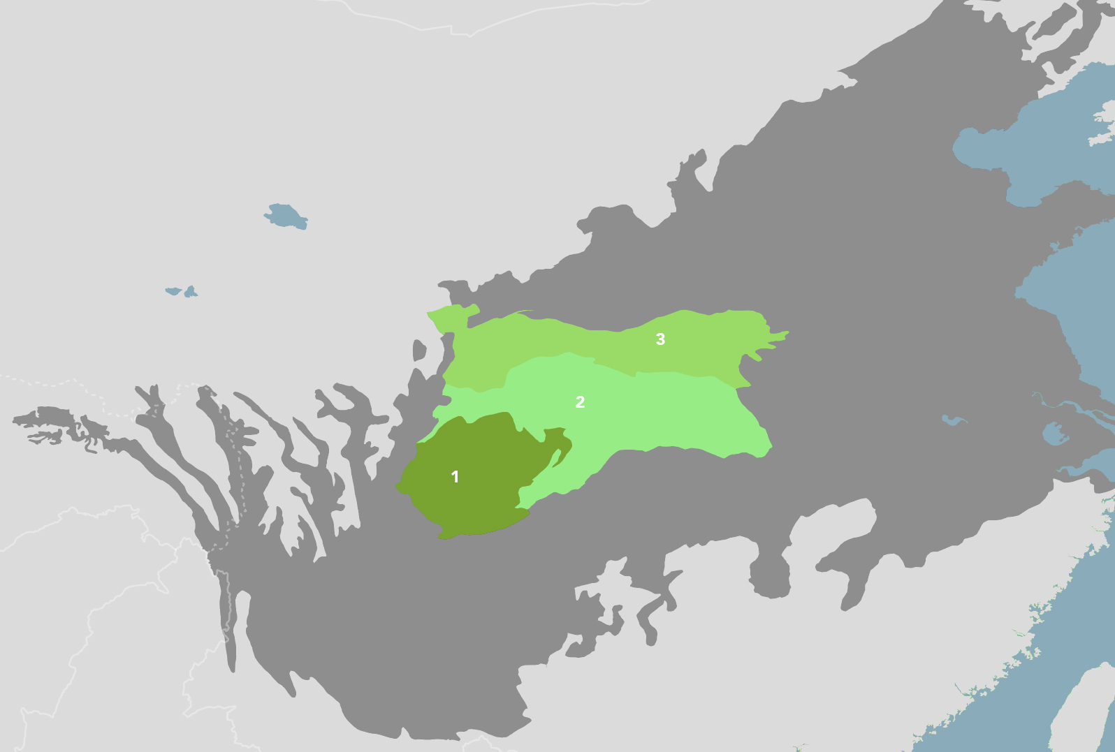
阿尔泰-萨彦山脉亚界 所含生物区和生态区 Altai-Sayan Mountains subrealm
阿尔泰-萨彦山脉亚界包含 Sayan Mountain Conifer Forests, Alpine Meadows & Steppe (PA36) 和 Altai Mountain Forests, Grasslands & Desert Steppe (PA37) 两个生物区,其中 PA37 涉及中国。
PA37:阿尔泰山
| Name of Bioregion | Altai Mountain Forests, Grasslands & Desert Steppe |
|---|---|
| 生物区名字 | 阿尔泰山森林、草原和沙漠草原 |

Altai Mountain Forests, Grasslands & Desert Steppe bioregion
(1) Altai Steppe and Semi-Desert (2) Altai Montane Forest and Forest Steppe (3) Altai Alpine Meadow and Tundra (4) Great Lakes Basin Desert Steppe.
PA0802:阿尔泰山(草原)
| Name of Ecoregion | Altai Steppe and Semi-Desert |
|---|---|
| 生态区名字 | 阿尔泰草原和半沙漠 |
Sources: WWF, World Species, One Earth, Wikipedia, EoE
PA0502✪:阿尔泰山(森林)
| Name of Ecoregion | Altai Montane Forest and Forest Steppe |
|---|---|
| 生态区名字 | 阿尔泰山地森林和森林草原 |
Sources: WWF, World Species, One Earth, Wikipedia, EoE
PA1001:阿尔泰山(冻原)
| Name of Ecoregion | Altai Alpine Meadow and Tundra |
|---|---|
| 生态区名字 | 阿尔泰高山草甸和冻原 |
Sources: WWF, World Species, One Earth, Wikipedia, EoE
⁜PA1316:乌布苏湖
| Name of Ecoregion | Great Lakes Basin Desert Steppe |
|---|---|
| 生态区名字 | 大湖盆地沙漠草原 |
Sources: WWF, World Species, One Earth, Wikipedia, EoE
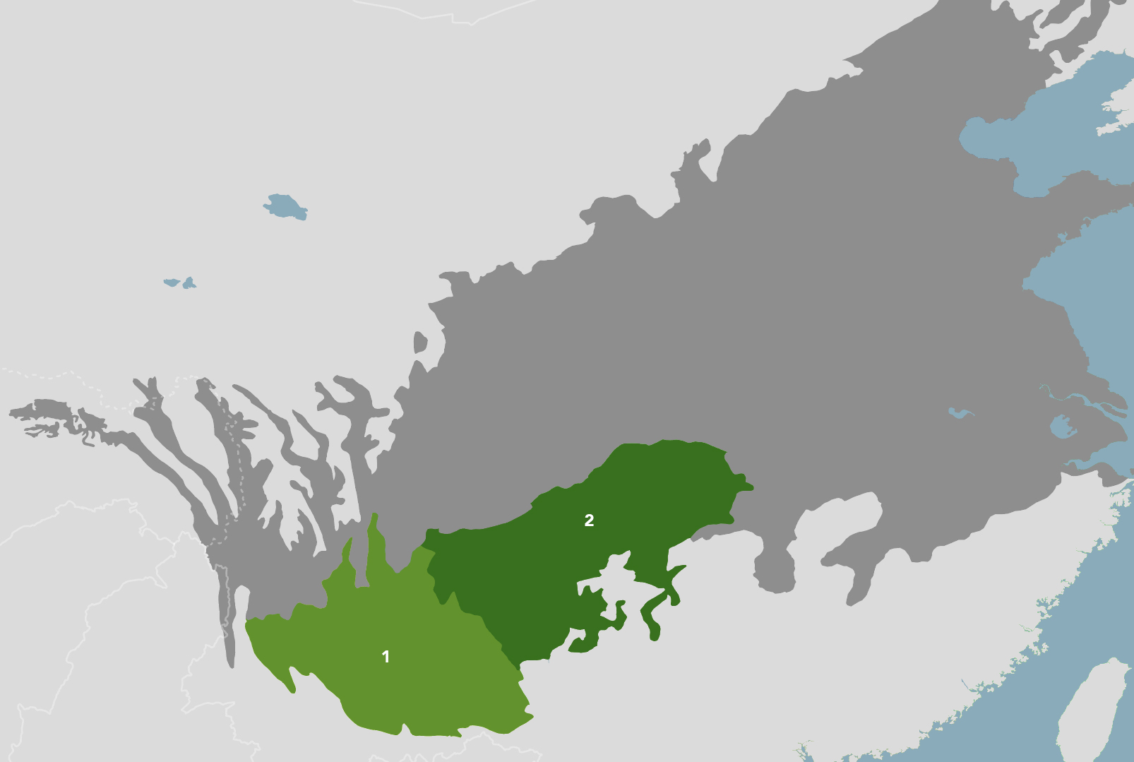
东亚荒漠亚界 所含生物区和生态区 East Asian Deserts subrealm
东亚荒漠亚界包含 Junggar Semi-Desert & Ermin Valley Steppe (PA38),Taklimakan Desert & Lowland Deciduous Forests (PA39) 和 Greater Gobi Desert (PA43) 三个生物区。
PA38:北疆
| Name of Bioregion | Junggar Semi-Desert & Ermin Valley Steppe |
|---|---|
| 生物区名字 | 准噶尔半沙漠和额敏河谷草原 |

Junggar Semi-Desert & Ermin Valley Steppe Bioregion
(1) Emin Valley Steppe (2) Junggar Basin Semi-Desert.
PA0806:额敏河谷
| Name of Ecoregion | Emin Valley Steppe |
|---|---|
| 生态区名字 | 额敏河谷草原 |
Sources: WWF, World Species, One Earth, Wikipedia, EoE
PA1317:准噶尔盆地
| Name of Ecoregion | Junggar Basin Semi-Desert |
|---|---|
| 生态区名字 | 准噶尔盆地半沙漠 |
Sources: WWF, World Species, One Earth, Wikipedia, EoE
PA39:南疆
| Name of Bioregion | Taklimakan Desert & Lowland Deciduous Forests |
|---|---|
| 生物区名字 | 塔克拉玛干沙漠和低地落叶林 |
Taklimakan Desert & Lowland Deciduous Forests Bioregion
(1) Tarim Basin Deciduous Forests and Steppe (2) Taklimakan Desert.
PA0442:塔里木盆地(绿洲)
| Name of Ecoregion | Tarim Basin Deciduous Forests and Steppe |
|---|---|
| 生态区名字 | 塔里木盆地落叶林和草原 |
Sources: WWF, World Species, One Earth, Wikipedia, EoE
PA1330:塔克拉玛干沙漠
| Name of Ecoregion | Taklimakan Desert |
|---|---|
| 生态区名字 | 塔克拉玛干沙漠 |
Sources: WWF, World Species, One Earth, Wikipedia, EoE
PA43:戈壁
| Name of Bioregion | Greater Gobi Desert |
|---|---|
| 生物区名字 | 戈壁沙漠 |
(1) Alashan Plateau Semi-Desert (2) Gobi Lakes Valley Desert Steppe (3) Eastern Gobi Desert Steppe.
PA1302:阿拉善沙漠
| Name of Ecoregion | Alashan Plateau Semi-Desert |
|---|---|
| 生态区名字 | 阿拉善高原半沙漠 |
Sources: WWF, World Species, One Earth, Wikipedia, EoE
⁜PA1315:戈壁湖谷
| Name of Ecoregion | Gobi Lakes Valley Desert Steppe |
|---|---|
| 生态区名字 | 戈壁湖谷沙漠草原 |
Sources: WWF, World Species, One Earth, Wikipedia, EoE
PA1314:戈壁东部(锡林郭勒、乌兰察布)
| Name of Ecoregion | Eastern Gobi Desert Steppe |
|---|---|
| 生态区名字 | 东部戈壁荒漠草原 |
Sources: WWF, World Species, One Earth, Wikipedia, EoE
青藏高原亚界 所含生物区和生态区 Tibetan Plateau subrealm
青藏高原亚界包含 Greater Tibetan Plateau Alpine Meadows & Shrublands (PA40) 和 Tibetan-Pamir Alpine Steppes, Shrublands & Mountain Forests (PA41) 两个生物区。
PA40:青藏高原主体
| Name of Bioregion | Greater Tibetan Plateau Alpine Meadows & Shrublands |
|---|---|
| 生物区名字 | 青藏高原高山草甸和灌丛 |
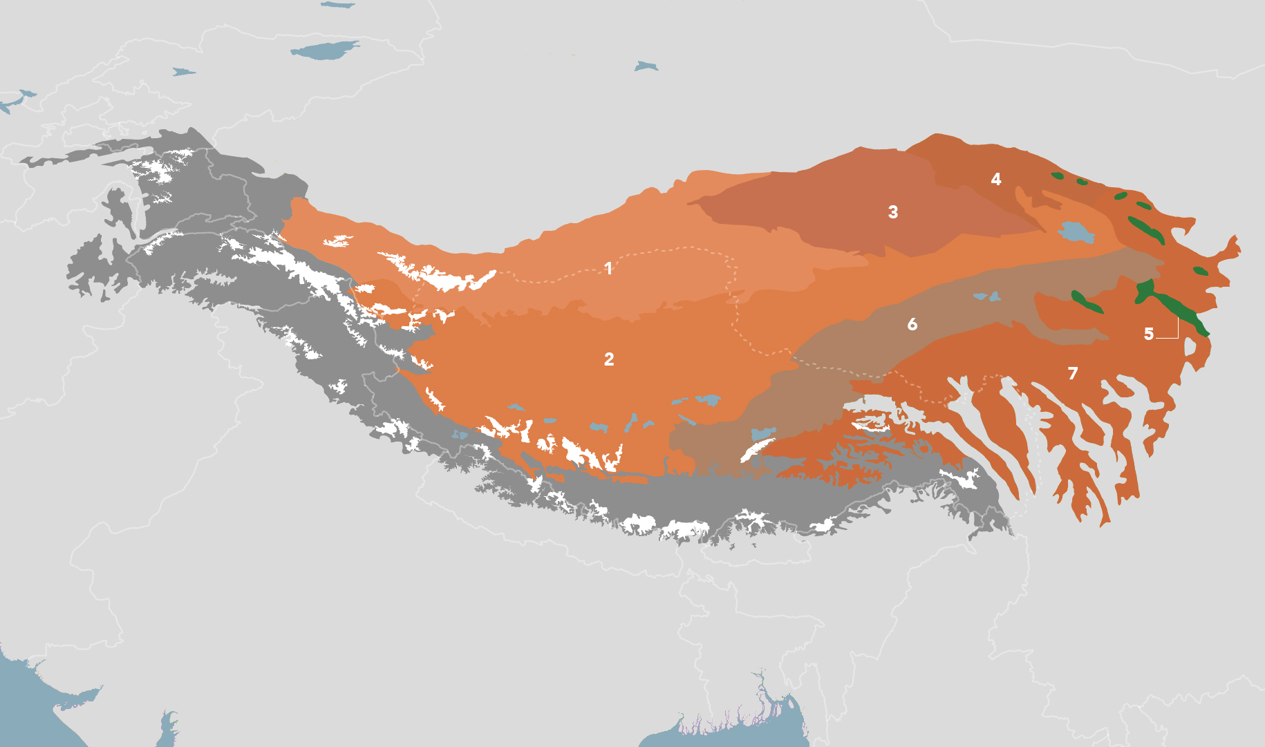
Greater Tibetan Plateau Alpine Meadows & Shrublands Bioregion
(1) North Tibetan Plateau-Kunlun Mountains Alpine Desert (2) Central Tibetan Plateau Alpine Steppe (3) Qaidam Basin Semi-Desert (4) Qilian Mountains Subalpine Meadows (5) Qilian Mountains Conifer Forests (6) Tibetan Plateau Alpine Shrublands and Meadows (7) Southeast Tibet Shrublands and Meadows.
PA1011✪:昆仑山
| Name of Ecoregion | North Tibetan Plateau-Kunlun Mountains Alpine Desert |
|---|---|
| 生态区名字 | 青藏高原北部昆仑山高寒荒漠 |
Sources: WWF, World Species, One Earth, Wikipedia, EoE
PA1002:青藏高原(高山草原)
| Name of Ecoregion | Central Tibetan Plateau Alpine Steppe |
|---|---|
| 生态区名字 | 青藏高原中部高山草原 |
Sources: WWF, World Species, One Earth, Wikipedia, EoE
PA1324:柴达木盆地
| Name of Ecoregion | Qaidam Basin Semi-Desert |
|---|---|
| 生态区名字 | 柴达木盆地半沙漠 |
Sources: WWF, World Species, One Earth, Wikipedia, EoE
PA1015✪:祁连山(草甸)
| Name of Ecoregion | Qilian Mountains Subalpine Meadows |
|---|---|
| 生态区名字 | 祁连山亚高山草甸 |
Sources: WWF, World Species, One Earth, Wikipedia, EoE
PA0517:祁连山(针叶林)
| Name of Ecoregion | Qilian Mountains Conifer Forests |
|---|---|
| 生态区名字 | 祁连山针叶林 |
Sources: WWF, World Species, One Earth, Wikipedia, EoE
PA1020✪:青藏高原(灌丛)
| Name of Ecoregion | Tibetan Plateau Alpine Shrublands and Meadows |
|---|---|
| 生态区名字 | 青藏高原高山灌丛和草甸 |
Sources: WWF, World Species, One Earth, Wikipedia, EoE
PA1017:藏东南、川西北
| Name of Ecoregion | Southeast Tibet Shrub and Meadows |
|---|---|
| 生态区名字 | 西藏东南部灌丛和草甸 |
Sources: WWF, World Species, One Earth, Wikipedia, EoE
PA41:帕米尔、青藏高原南部山地
| Name of Bioregion | Tibetan-Pamir Alpine Steppes, Shrublands & Mountain Forests |
|---|---|
| 生物区名字 | 青藏高原帕米尔高原高山草原、灌丛和山地森林 |
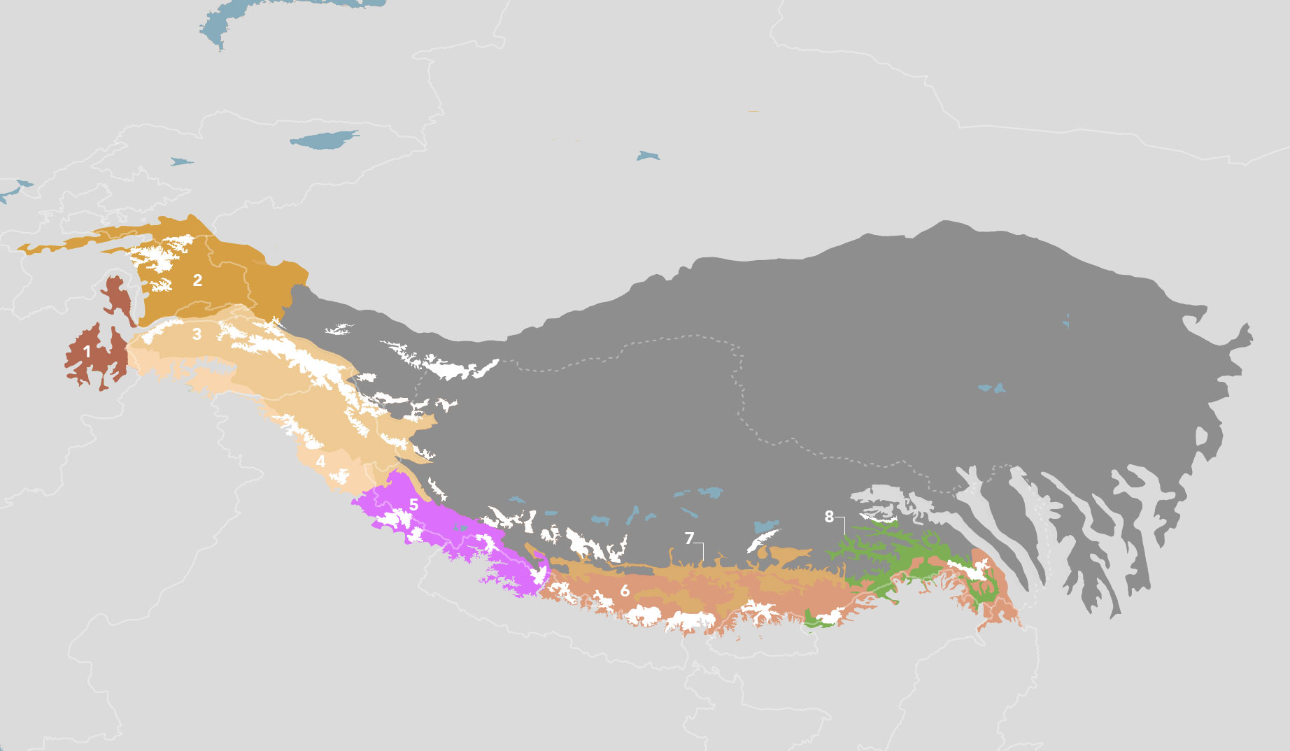
Tibetan-Pamir Alpine Steppes, Shrublands & Mountain Forests Bioregion
(1) Hindu Kush Alpine Meadow (2) Pamir Alpine Desert and Tundra (3) Karakoram-West Tibetan Plateau Alpine Steppe (4) Northwestern Himalayan Alpine Shrub and Meadows (5) Western Himalayan Alpine Shrub and Meadows (6) Eastern Himalayan Alpine Shrub and Meadows (7) Yarlung Zangbo Arid Steppe (8) Northeastern Himalayan Subalpine Conifer Forests.
⁜PA1005:兴都库什山(草甸)
| Name of Ecoregion | Hindu Kush Alpine Meadow |
|---|---|
| 生态区名字 | 兴都库什高山草甸 |
Sources: WWF, World Species, One Earth, Wikipedia, EoE
PA1014:帕米尔(冻原)
| Name of Ecoregion | Pamir Alpine Desert and Tundra |
|---|---|
| 生态区名字 | 帕米尔高寒荒漠和冻原 |
Sources: WWF, World Species, One Earth, Wikipedia, EoE
PA1006:喀喇昆仑山(高山草原)
| Name of Ecoregion | Karakoram-West Tibetan Plateau Alpine Steppe |
|---|---|
| 生态区名字 | 喀喇昆仑-青藏高原西部高山草原 |
Sources: WWF, World Species, One Earth, Wikipedia, EoE
PA1012:喜马拉雅西北部(灌丛)
| Name of Ecoregion | Northwestern Himalayan Alpine Shrub and Meadows |
|---|---|
| 生态区名字 | 喜马拉雅西北部高山灌丛和草甸 |
Sources: WWF, World Species, One Earth, Wikipedia, EoE
PA1021:喜马拉雅西部(灌丛)
| Name of Ecoregion | Western Himalayan Alpine Shrub and Meadows |
|---|---|
| 生态区名字 | 喜马拉雅西部高山灌丛和草甸 |
Sources: WWF, World Species, One Earth, Wikipedia, EoE
PA1003✪:喜马拉雅东部(灌丛)
| Name of Ecoregion | Eastern Himalayan Alpine Shrub and Meadows |
|---|---|
| 生态区名字 | 喜马拉雅东部高山灌丛和草甸 |
Sources: WWF, World Species, One Earth, Wikipedia, EoE
PA1022:雅鲁藏布(草原)
| Name of Ecoregion | Yarlung Zangbo Arid Steppe |
|---|---|
| 生态区名字 | 雅鲁藏布干旱草原 |
Sources: WWF, World Species, One Earth, Wikipedia, EoE
PA0514:喜马拉雅东北部(针叶林)
| Name of Ecoregion | Northeastern Himalayan Subalpine Conifer Forests |
|---|---|
| 生态区名字 | 喜马拉雅东北部亚高山针叶林 |
Sources: WWF, World Species, One Earth, Wikipedia, EoE
蒙古草原亚界 所含生物区和生态区 Mongolian Grasslands subrealm
蒙古草原亚界包含 Ordos Plateau Steppe & Mountain Conifer Forests (PA42) 和 Mongolian Grasslands, Alpine Meadows & Forest Steppe (PA44) 两个生物区。
PA42:陕甘宁盆地
| Name of Bioregion | Ordos Plateau Steppe & Mountain Conifer Forests |
|---|---|
| 生物区名字 | 鄂尔多斯高原草原和山地针叶林 |
Ordos Plateau Steppe & Mountain Conifer Forests Bioregion
(1) Helanshan Montane Conifer Forests (2) Ordos Plateau Steppe.
PA0508:贺兰山
| Name of Ecoregion | Helanshan Montane Conifer Forests |
|---|---|
| 生态区名字 | 贺兰山山地针叶林 |
Sources: WWF, World Species, One Earth, Wikipedia, EoE
PA1013✪:鄂尔多斯(荒漠草原)
| Name of Ecoregion | Ordos Plateau Steppe |
|---|---|
| 生态区名字 | 鄂尔多斯高原草原 |
Sources: WWF, World Species, One Earth, Wikipedia, EoE
PA44:蒙古草原
| Name of Bioregion | Mongolian Grasslands, Alpine Meadows & Forest Steppe |
|---|---|
| 生物区名字 | 蒙古草原、高山草甸和森林草原 |

Mongolian Grasslands, Alpine Meadows & Forest Steppe Bioregion
(1) Selenge-Orkhon Forest Steppe (2) Khangai Mountains Alpine Meadow (3) Khangai Mountains Conifer Forests (4) Mongolian-Manchurian Grassland (5) Daurian Forest Steppe (6) Nenjiang River Grassland.
⁜PA0816:色楞格河、鄂尔浑河
| Name of Ecoregion | Selenge-Orkhon Forest Steppe |
|---|---|
| 生态区名字 | 色楞格-鄂尔浑河森林草原 |
Sources: WWF, World Species, One Earth, Wikipedia, EoE
⁜PA1007:杭爱山(高山草甸)
| Name of Ecoregion | Khangai Mountains Alpine Meadow |
|---|---|
| 生态区名字 | 杭爱山高山草甸 |
Sources: WWF, World Species, One Earth, Wikipedia, EoE
⁜PA0512:杭爱山(针叶林)
| Name of Ecoregion | Khangai Mountains Conifer Forests |
|---|---|
| 生态区名字 | 杭爱山针叶林 |
Sources: WWF, World Species, One Earth, Wikipedia, EoE
PA0813:蒙古高原草原、内蒙古草原、东北草原
| Name of Ecoregion | Mongolian-Manchurian Grassland |
|---|---|
| 生态区名字 | 蒙古-满洲草原 |
Sources: WWF, World Species, One Earth, Wikipedia, EoE
PA0804✪:达斡尔山脉/外贝加尔山脉
| Name of Ecoregion | Daurian Forest Steppe |
|---|---|
| 生态区名字 | 达斡尔森林草原 |
Sources: WWF, World Species, One Earth, Wikipedia, EoE
PA0903:嫩江(草原)
| Name of Ecoregion | Nenjiang River Grassland |
|---|---|
| 生态区名字 | 嫩江草原 |
Sources: WWF, World Species, One Earth, Wikipedia, EoE
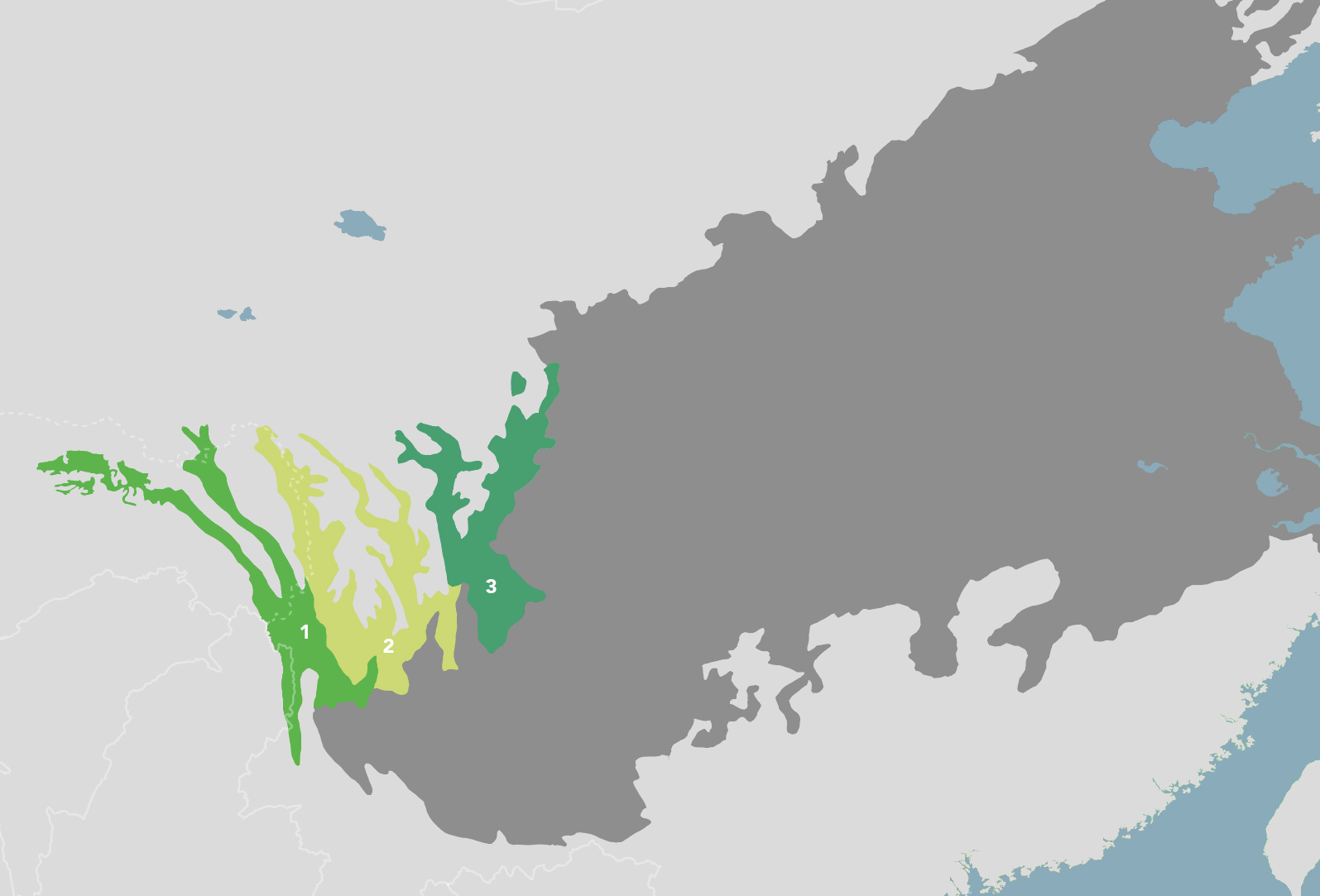
东北亚森林亚界 所含生物区和生态区 Northeast Asian Forests subrealm
东北亚森林亚界包含 Dzhagdy Mountain Conifer Forests (PA45),Manchuria-Ussuri Mixed Forests & Meadow Steppes (PA46) 和 Korean Peninsula Mixed Forests (PA48) 三个生物区,其中 PA45 和 PA46 涉及中国。
PA45:大兴安岭
| Name of Bioregion | Dzhagdy Mountain Conifer Forests |
|---|---|
| 生物区名字 | 贾格德山针叶林 |
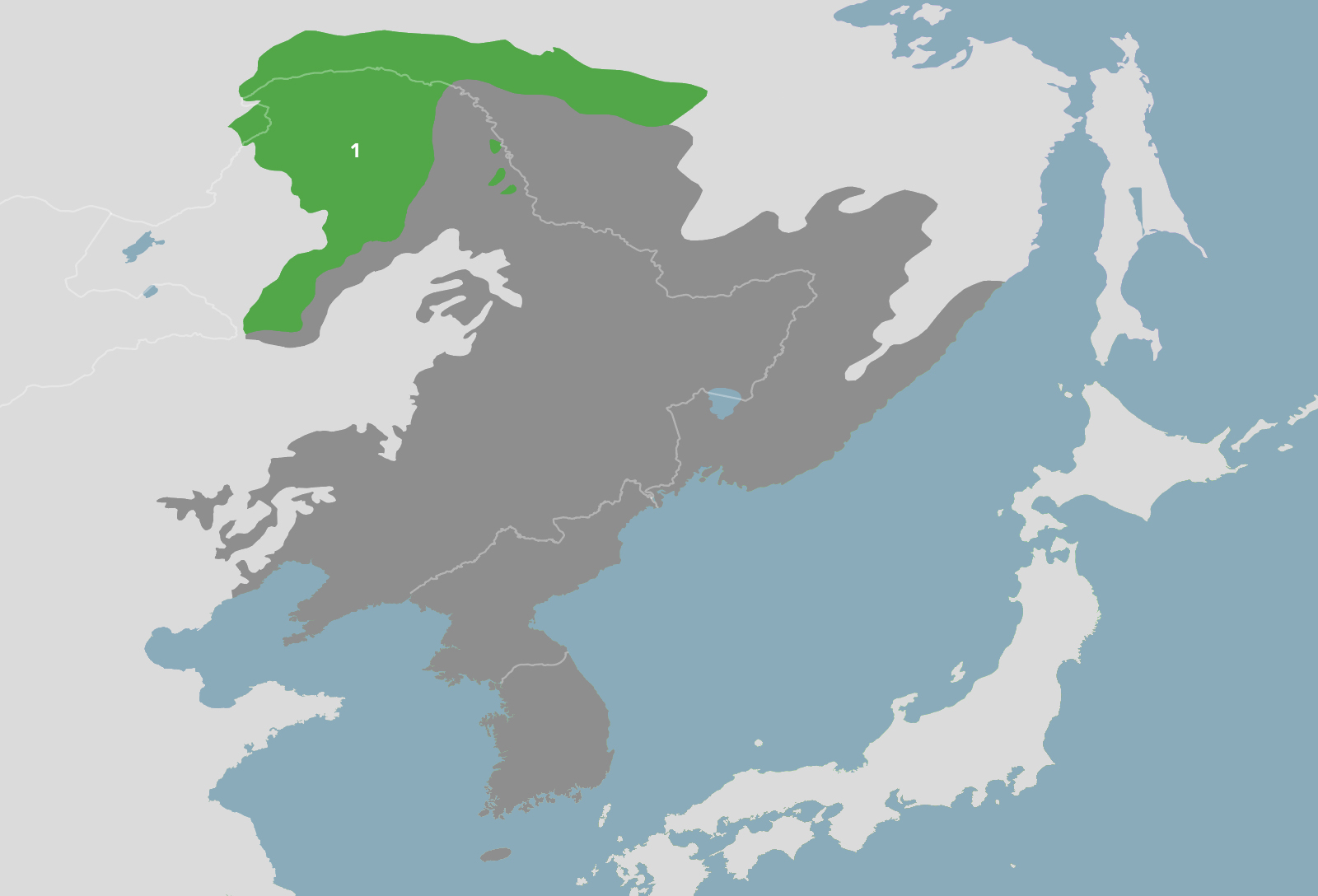
Dzhagdy Mountain Conifer Forests Bioregion
(1) Da Hinggan-Dzhagdy Mountains Conifer Forests.
PA0505:大兴安岭(针叶林)
| Name of Ecoregion | Da Hinggan-Dzhagdy Mountains Conifer Forests |
|---|---|
| 生态区名字 | 大兴安岭-贾格德山针叶林 |
Sources: WWF, World Species, One Earth, Wikipedia, EoE
PA46:东北地区
| Name of Bioregion | Manchuria-Ussuri Mixed Forests & Meadow Steppes |
|---|---|
| 生物区名字 | 满洲-乌苏里江混交林和草甸草原 |
Manchuria-Ussuri Mixed Forests & Meadow Steppes Bioregion
(1) Northeast China Plain Deciduous Forests (2) Changbai Mountains Mixed Forests (3) Manchurian Mixed Forests (4) Suiphun-Khanka Meadows and Forest Meadows (5) Amur Meadow Steppe (6) Ussuri Broadleaf and Mixed Forests.
PA0430:松嫩平原、辽河平原(落叶林)
| Name of Ecoregion | Northeast China Plain Deciduous Forests |
|---|---|
| 生态区名字 | 东北平原落叶林 |
Sources: WWF, World Species, One Earth, Wikipedia, EoE
PA0414:长白山(混交林)
| Name of Ecoregion | Changbai Mountains Mixed Forests |
|---|---|
| 生态区名字 | 长白山混交林 |
Sources: WWF, World Species, One Earth, Wikipedia, EoE
PA0426:东北(混交林)
| Name of Ecoregion | Manchurian Mixed Forests |
|---|---|
| 生态区名字 | 满洲混交林 |
Sources: WWF, World Species, One Earth, Wikipedia, EoE
PA0907:绥芬河、兴凯湖(草甸)
| Name of Ecoregion | Suiphun-Khanka Meadows and Forest Meadows |
|---|---|
| 生态区名字 | 绥芬河-兴凯湖草甸和森林草甸 |
Sources: WWF, World Species, One Earth, Wikipedia, EoE
PA0901:三江平原(草甸)
| Name of Ecoregion | Amur Meadow Steppe |
|---|---|
| 生态区名字 | 阿穆尔草甸草原 |
Sources: WWF, World Species, One Earth, Wikipedia, EoE
⁜PA0443✪:乌苏里江
| Name of Ecoregion | Ussuri Broadleaf and Mixed Forests |
|---|---|
| 生态区名字 | 乌苏里阔叶林和混交林 |
Sources: WWF, World Species, One Earth, Wikipedia, EoE
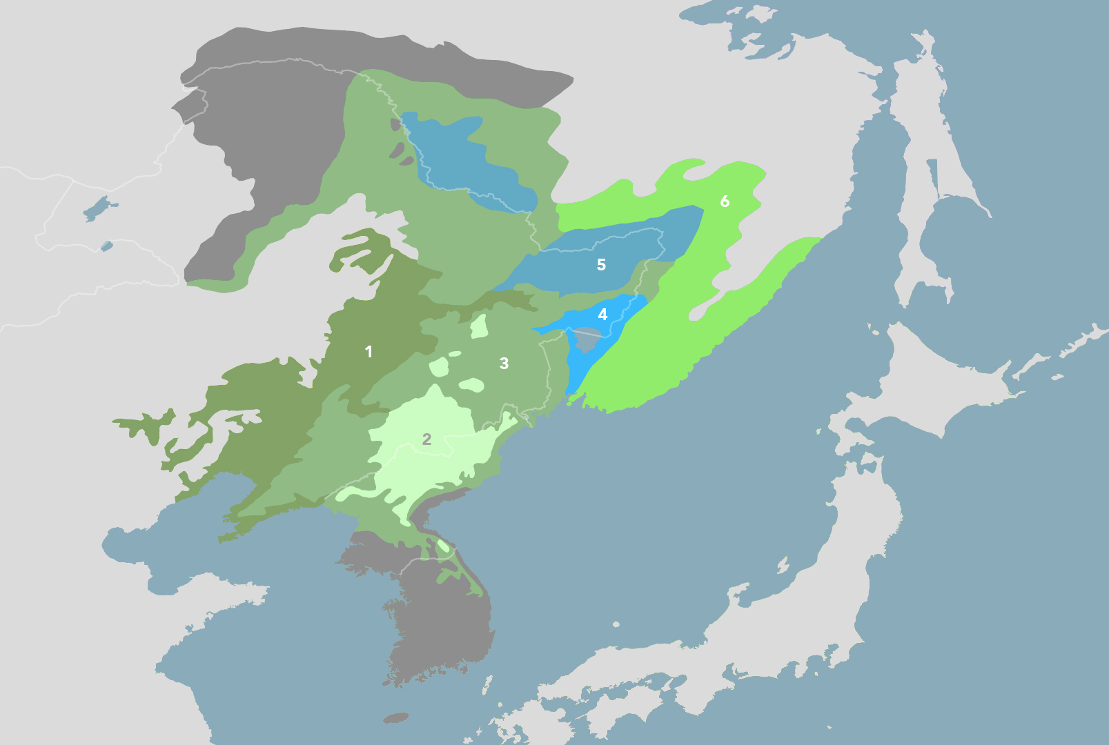
东亚中部森林亚界 所含生物区和生态区 Central East Asian Forests subrealm
东亚中部森林亚界包含 Loess Plateau & Huang He Plain Mixed Forests (PA49),Chang Jiang Plain Evergreen Forests (PA50),Sichuan Basin & Central Mountain Forests (PA51),Guizhou & Yunnan Subtropical Forest Plateaus (PA52) 和 Hengduan Mountain Conifer Forests (PA53) 五个生物区。
PA49:黄河中下游
| Name of Bioregion | Loess Plateau & Huang He Plain Mixed Forests |
|---|---|
| 生物区名字 | 黄土高原黄河平原混交林 |
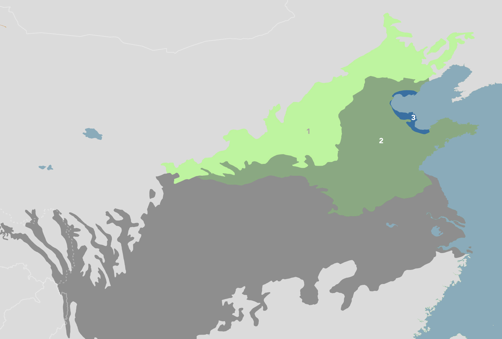
Loess Plateau & Huang He Plain Mixed Forests Bioregion
(1) Central China Loess Plateau Mixed Forests (2) Huang He Plain Mixed Forests (3) Bohai Sea Saline Meadow.
PA0411:黄土高原
| Name of Ecoregion | Central China Loess Plateau Mixed Forests |
|---|---|
| 生态区名字 | 华中黄土高原混交林 |
Sources: WWF, World Species, One Earth, Wikipedia, EoE
PA0424:华北平原
| Name of Ecoregion | Huang He Plain Mixed Forests |
|---|---|
| 生态区名字 | 黄河平原混交林 |
Sources: WWF, World Species, One Earth, Wikipedia, EoE
PA0902:渤海湾沿岸
| Name of Ecoregion | Bohai Sea Saline Meadow |
|---|---|
| 生态区名字 | 渤海盐碱草甸 |
Sources: WWF, World Species, One Earth, Wikipedia, EoE
PA50:长江中下游
| Name of Bioregion | Chang Jiang Plain Evergreen Forests |
|---|---|
| 生物区名字 | 长江中下游平原常绿林 |

Chang Jiang Plain Evergreen Forests Bioregion
(1) Changjiang Plain Evergreen Forests (2) Yellow Sea Saline Meadow.
PA0415:长江中下游平原
| Name of Ecoregion | Changjiang Plain Evergreen Forests |
|---|---|
| 生态区名字 | 长江中下游平原常绿林 |
Sources: WWF, World Species, One Earth, Wikipedia, EoE
PA0908:黄海沿岸
| Name of Ecoregion | Yellow Sea Saline Meadow |
|---|---|
| 生态区名字 | 黄海盐碱草甸 |
Sources: WWF, World Species, One Earth, Wikipedia, EoE
PA51:长江上游
| Name of Bioregion | Sichuan Basin & Central Mountain Forests |
|---|---|
| 生物区名字 | 四川盆地和中部山林 |
Sichuan Basin & Central Mountain Forests Bioregion
(1) Sichuan Basin Evergreen Broadleaf Forests (2) Daba Mountains Evergreen Forests (3) Qin Ling Mountains Deciduous Forests.
PA0437✪:四川盆地
| Name of Ecoregion | Sichuan Basin Evergreen Broadleaf Forests |
|---|---|
| 生态区名字 | 四川盆地常绿阔叶林 |
Sources: WWF, World Species, One Earth, Wikipedia, EoE
PA0417✪:大巴山
| Name of Ecoregion | Daba Mountains Evergreen Forests |
|---|---|
| 生态区名字 | 大巴山常绿林 |
Sources: WWF, World Species, One Earth, Wikipedia, EoE
PA0434✪:秦岭
| Name of Ecoregion | Qin Ling Mountains Deciduous Forests |
|---|---|
| 生态区名字 | 秦岭落叶林 |
Sources: WWF, World Species, One Earth, Wikipedia, EoE
PA52:云贵高原
| Name of Bioregion | Guizhou & Yunnan Subtropical Forest Plateaus |
|---|---|
| 生物区名字 | 云贵高原亚热带森林 |
Guizhou & Yunnan Subtropical Forest Plateaus Bioregion
(1) Yunnan Plateau Subtropical Evergreen Forests (2) Guizhou Plateau Broadleaf and Mixed Forests.
PA0102:云南高原
| Name of Ecoregion | Yunnan Plateau Subtropical Evergreen Forests |
|---|---|
| 生态区名字 | 云南高原亚热带常绿林 |
Sources: WWF, World Species, One Earth, Wikipedia, EoE
PA0101:贵州高原
| Name of Ecoregion | Guizhou Plateau Broadleaf and Mixed Forests |
|---|---|
| 生态区名字 | 贵州高原阔叶林和混交林 |
Sources: WWF, World Species, One Earth, Wikipedia, EoE
PA53:横断山脉
| Name of Bioregion | Hengduan Mountain Conifer Forests |
|---|---|
| 生物区名字 | 横断山脉针叶林 |
Hengduan Mountain Conifer Forests Bioregion
(1) Nujiang Lancang Gorge Subalpine Conifer and Mixed Forests (2) Hengduan Mountains Subalpine Conifer Forests (3) Qionglai-Minshan Conifer Forests.
PA0516:怒江、澜沧江峡谷
| Name of Ecoregion | Nujiang Lancang Gorge Alpine Conifer and Mixed Forests |
|---|---|
| 生态区名字 | 怒江-澜沧江峡谷高山针叶林和混交林 |
Sources: WWF, World Species, One Earth, Wikipedia, EoE
PA0509✪:横断山
| Name of Ecoregion | Hengduan Mountains Subalpine Conifer Forests |
|---|---|
| 生态区名字 | 横断山脉亚高山针叶林 |
Sources: WWF, World Species, One Earth, Wikipedia, EoE
PA0518:邛崃山、岷山
| Name of Ecoregion | Qionglai-Minshan Conifer Forests |
|---|---|
| 生态区名字 | 邛崃山-岷山针叶林 |
Sources: WWF, World Species, One Earth, Wikipedia, EoE
东南亚森林亚界 所含生物区和生态区 Southeast Asian Forests subrealm
东南亚森林亚界属于东洋界 (Indomalaya),包含 Myanmar Coastal Rainforests & Andaman Sea Islands (IM9),Arakan Mountains & Northern Triangle Forests (IM10),Irrawaddy & North Indochina Mixed Forests (IM11),Indochina Mixed Forests & Peatlands (IM12),South China Subtropical Evergreen & Monsoon Forests (IM13),Nansei Islands Subtropical Evergreen Forests (IM14) 和 Philippines & Sulu Sea Tropical Forests (IM15) 五个生物区,其中 IM11、IM12 和 IM13 涉及中国。
IM11:印度支那半岛北部
| Name of Bioregion | Irrawaddy & North Indochina Mixed Forests |
|---|---|
| 生物区名字 | 伊洛瓦底江和印度支那北部混交林 |

Irrawaddy & North Indochina Mixed Forests Bioregion
(1) Irrawaddy Moist Deciduous Forests (2) Irrawaddy Dry Forests (3) Northern Indochina Subtropical Forests (4) Kayah-Karen Montane Rainforests.
⁜IM0117:伊洛瓦底江(落叶林)
| Name of Ecoregion | Irrawaddy Moist Deciduous Forests |
|---|---|
| 生态区名字 | 伊洛瓦底江湿润落叶林 |
Sources: WWF, World Species, One Earth, Wikipedia, EoE
⁜IM0205:伊洛瓦底江(旱生林)
| Name of Ecoregion | Irrawaddy Dry Forests |
|---|---|
| 生态区名字 | 伊洛瓦底江旱生林 |
Sources: WWF, World Species, One Earth, Wikipedia, EoE
IM0137:云南南部边境
| Name of Ecoregion | Northern Indochina Subtropical Forests |
|---|---|
| 生态区名字 | 印度支那北部亚热带森林 |
Sources: WWF, World Species, One Earth, Wikipedia, EoE
⁜IM0119✪:克耶-卡伦山
| Name of Ecoregion | Kayah-Karen Montane Rainforests |
|---|---|
| 生态区名字 | 克耶-卡伦山山地雨林 |
Sources: WWF, World Species, One Earth, Wikipedia, EoE
IM12:印度支那半岛南部
| Name of Bioregion | Indochina Mixed Forests & Peatlands |
|---|---|
| 生物区名字 | 印度支那混交林和泥炭沼泽 |
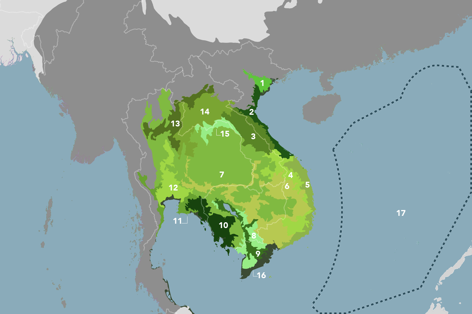
Indochina Mixed Forests & Peatlands Bioregion
(1) Red River Freshwater Swamp Forests (2) Northern Vietnam Lowland Rainforests (3) Northern Annamites Rainforests (4) Southern Annamites Montane Rainforests (5) Southern Vietnam Lowland Dry Forests (6) Southeastern Indochina Dry Evergreen Forests (7) Central Indochina Dry Forests (8) Tonle Sap-Mekong Peat Swamp Forest (9) Tonle Sap Freshwater Swamp Forests (10) Cardamom Mountains Rainforests (11) Chao Phraya Lowland Moist Deciduous Forests (12) Chao Phraya Freshwater Swamp Forests (13) Northern Thailand-Laos Moist Deciduous Forests (14) Luang Prabang Montane Rainforests (15) Northern Khorat Plateau Moist Deciduous Forests (16) Indochina Mangroves (17) South China Sea Islands.
⁜IM0147:红河三角洲
| Name of Ecoregion | Red River Freshwater Swamp Forests |
|---|---|
| 生态区名字 | 红河淡水沼泽森林 |
Sources: WWF, World Species, One Earth, Wikipedia, EoE
⁜IM0141:越南北部沿海(雨林)
| Name of Ecoregion | Northern Vietnam Lowland Rainforests |
|---|---|
| 生态区名字 | 越南北部低地雨林 |
Sources: WWF, World Species, One Earth, Wikipedia, EoE
⁜IM0136✪:安南山脉北部
| Name of Ecoregion | Northern Annamites Rainforests |
|---|---|
| 生态区名字 | 安南山脉北部雨林 |
Sources: WWF, World Species, One Earth, Wikipedia, EoE
⁜IM0152✪:安南山脉南部
| Name of Ecoregion | Southern Annamites Montane Rainforests |
|---|---|
| 生态区名字 | 安南山脉南部山地雨林 |
Sources: WWF, World Species, One Earth, Wikipedia, EoE
⁜IM0211:越南南部沿海(旱生林)
| Name of Ecoregion | Southern Vietnam Lowland Dry Forests |
|---|---|
| 生态区名字 | 越南南部低地旱生林 |
Sources: WWF, World Species, One Earth, Wikipedia, EoE
⁜IM0210:印度支那东南部(旱生林)
| Name of Ecoregion | Southeastern Indochina Dry Evergreen Forests |
|---|---|
| 生态区名字 | 印度支那东南部旱生常绿林 |
Sources: WWF, World Species, One Earth, Wikipedia, EoE
⁜IM0202✪:印度支那中部(旱生林)
| Name of Ecoregion | Central Indochina Dry Forests |
|---|---|
| 生态区名字 | 印度支那中部旱生林 |
Sources: WWF, World Species, One Earth, Wikipedia, EoE
⁜IM0165:洞里萨湖(泥炭沼泽)
| Name of Ecoregion | Tonle Sap-Mekong Peat Swamp Forest |
|---|---|
| 生态区名字 | 洞里萨湖-湄公河泥炭沼泽森林 |
Sources: WWF, World Species, One Earth, Wikipedia, EoE
⁜IM0164:洞里萨湖(淡水沼泽)
| Name of Ecoregion | Tonle Sap Freshwater Swamp Forests |
|---|---|
| 生态区名字 | 洞里萨湖淡水沼泽森林 |
Sources: WWF, World Species, One Earth, Wikipedia, EoE
⁜IM0106✪:豆蔻山脉
| Name of Ecoregion | Cardamom Mountains Rainforests |
|---|---|
| 生态区名字 | 豆蔻山脉雨林 |
Sources: WWF, World Species, One Earth, Wikipedia, EoE
⁜IM0108:湄南河(落叶林)
| Name of Ecoregion | Chao Phraya Lowland Moist Deciduous Forests |
|---|---|
| 生态区名字 | 昭披耶河低地湿润落叶林 |
Sources: WWF, World Species, One Earth, Wikipedia, EoE
⁜IM0107:湄南河(沼泽森林)
| Name of Ecoregion | Chao Phraya Freshwater Swamp Forests |
|---|---|
| 生态区名字 | 昭披耶河淡水沼泽森林 |
Sources: WWF, World Species, One Earth, Wikipedia, EoE
⁜IM0139:泰国北部、老挝北部
| Name of Ecoregion | Northern Thailand-Laos Moist Deciduous Forests |
|---|---|
| 生态区名字 | 泰国北部-老挝湿润落叶林 |
Sources: WWF, World Species, One Earth, Wikipedia, EoE
⁜IM0121:龙坡邦山脉
| Name of Ecoregion | Luang Prabang Montane Rainforests |
|---|---|
| 生态区名字 | 龙坡邦山脉山地雨林 |
Sources: WWF, World Species, One Earth, Wikipedia, EoE
⁜IM0138:呵叻高原北部
| Name of Ecoregion | Northern Khorat Plateau Moist Deciduous Forests |
|---|---|
| 生态区名字 | 呵叻高原北部湿润落叶林 |
Sources: WWF, World Species, One Earth, Wikipedia, EoE
⁜IM1402:印度支那沿海(红树林)
| Name of Ecoregion | Indochina Mangroves |
|---|---|
| 生态区名字 | 印度支那红树林 |
Sources: WWF, World Species, One Earth, Wikipedia, EoE
IM0148:南海
| Name of Ecoregion | South China Sea Islands |
|---|---|
| 生态区名字 | 南海诸岛 |
Sources: WWF, World Species, One Earth, Wikipedia, EoE
IM13:华南
| Name of Bioregion | South China Subtropical Evergreen & Monsoon Forests |
|---|---|
| 生物区名字 | 华南亚热带常绿林与季风林 |
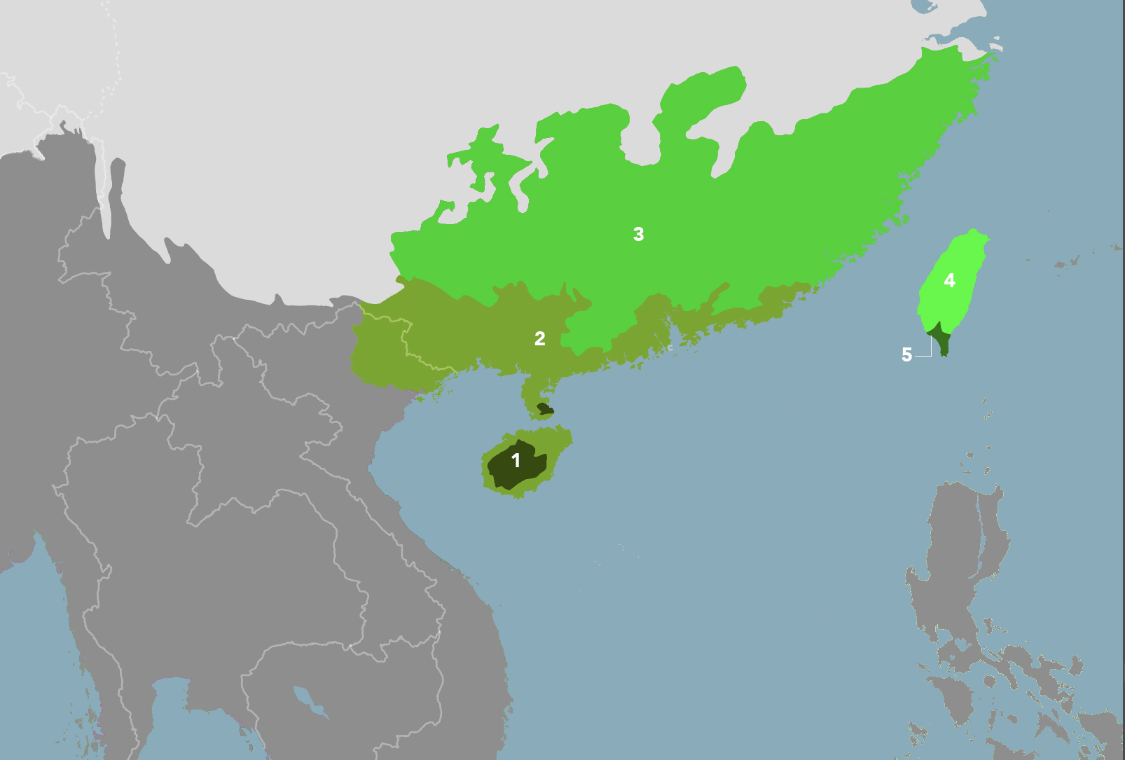
South China Subtropical Evergreen & Monsoon Forests Bioregion
(1) Hainan Island Monsoon Rain Forests (2) South China-Vietnam Subtropical Evergreen Forests (3) Jian Nan Subtropical Evergreen Forests (4) Taiwan Subtropical Evergreen Forests (5) South Taiwan Monsoon Rain Forests.
IM0169✪:海南岛
| Name of Ecoregion | Hainan Island Monsoon Rain Forests |
|---|---|
| 生态区名字 | 海南岛季风雨林 |
Sources: WWF, World Species, One Earth, Wikipedia, EoE
IM0149✪:华南南部
| Name of Ecoregion | South China-Vietnam Subtropical Evergreen Forests |
|---|---|
| 生态区名字 | 华南-越南亚热带常绿林 |
Sources: WWF, World Species, One Earth, Wikipedia, EoE
IM0118:华南北部
| Name of Ecoregion | Jian Nan Subtropical Evergreen Forests |
|---|---|
| 生态区名字 | 江南亚热带常绿林 |
Sources: WWF, World Species, One Earth, Wikipedia, EoE
IM0172✪:台湾岛(常绿林)
| Name of Ecoregion | Taiwan Subtropical Evergreen Forests |
|---|---|
| 生态区名字 | 台湾岛亚热带常绿林 |
Sources: WWF, World Species, One Earth, Wikipedia, EoE
IM0171:台湾岛(季风雨林)
| Name of Ecoregion | South Taiwan Monsoon Rain Forests |
|---|---|
| 生态区名字 | 台湾岛南部季风雨林 |
Sources: WWF, World Species, One Earth, Wikipedia, EoE
中国的生物群系 Biomes in China
中国境内共有 7 种生物群系。
| 生物群系名称 | Name of Biome | 生物群系简称 Biome Label |
|---|---|---|
| 热带和亚热带常绿阔叶林 | (Sub)Tropical moist broadleaf forests | TropMoist |
| 温带阔叶林和混交林 | Temperate broadleaf and mixed forests | TempBroad |
| 温带针叶林 | Temperate coniferous forest | TempConifer |
| 温带草地、稀树草原和灌丛 | Temperate grasslands, savannas and shrublands | TempGrass |
| 水泛滥的草地和稀树草原 | Flooded grasslands and savannas | FloodGrass |
| 山地草原和灌丛 | Montane grasslands and shrublands | MontGrass |
| 荒漠和干燥疏灌丛 | Deserts and xeric shrublands | Desert |
中国的生态区 Ecoregions in China
以下为中国的所有生态区,包括仅部分在中国境内的生态区。其中,✪ 标注的生态区入选 WWF 的 Global 200 计划。Global 200 计划涵盖了世界上最重要的 200 余个生态区,作为生态保护的重点地区。
中国的世界遗产 World Heritage Sites in China
以下为中国的世界遗产(自然类和混合类),以及所处的生态区。
| Dossier / 编号 | Name of UNESCO World Heritage | 世界遗产名称 | Type / 类别 | Ecoregion / 生态区 |
|---|---|---|---|---|
| 437 | Mount Taishan | 泰山 | Mixed | PA0424 |
| 547 | Mount Huangshan | 黄山 | Mixed | PA0415 |
| 637 | Jiuzhaigou Valley Scenic and Historic Interest Area | 九寨沟风景名胜区 | Natural | PA1017 |
| 638 | Huanglong Scenic and Historic Interest Area | 黄龙风景名胜区 | Natural | PA1017, PA0518 |
| 640 | Wulingyuan Scenic and Historic Interest Area | 武陵源风景名胜区 | Natural | PA0101 |
| 779 | Mount Emei Scenic Area, including Leshan Giant Buddha Scenic Area | 峨眉山—乐山大佛 | Mixed | PA0437 |
| 911 | Mount Wuyi | 武夷山 | Mixed | IM0118 |
| 1083 | Three Parallel Rivers of Yunnan Protected Areas | 云南三江并流保护区 | Natural | PA0516, PA0509 |
| 1213 | Sichuan Giant Panda Sanctuaries | 四川大熊猫栖息地 | Natural | PA1017, PA0518 |
| 1248 | South China Karst | 中国南方喀斯特 | Natural | PA0102, PA0101 |
| 1292 | Mount Sanqingshan National Park | 三清山国家公园 | Natural | PA0415 |
| 1335 | China Danxia | 中国丹霞 | Natural | PA0415, IM0118 |
| 1388 | Chengjiang Fossil Site | 澄江化石遗址 | Natural | PA0102 |
| 1414 | Xinjiang Tianshan | 新疆天山 | Natural | PA0521, PA1019 |
| 1509 | Hubei Shennongjia | 湖北神农架 | Natural | PA0417 |
| 1540 | Qinghai Hoh Xil | 青海可可西里 | Natural | PA1011, PA1002 |
| 1559 | Fanjingshan | 梵净山 | Natural | PA0101, IM0118 |
| 1606 | Migratory Bird Sanctuaries along the Coast of Yellow Sea-Bohai Gulf of China (Phase I) | 中国黄(渤)海候鸟栖息地(第一期) | Natural | PA0908 |
References
Biogeographic realm - Wikipedia
Lists of ecoregions - Wikipedia
File:Biomes of the world.svg - Wikimedia Commons
List of ecoregions in China - Wikipedia
Digital Observatory for Protected Areas (DOPA) Explorer - European Commission
List of World Heritage Sites in China - Wikipedia